Criminals Target Stores with Easy Access to Major Arteries
January 18, 2013
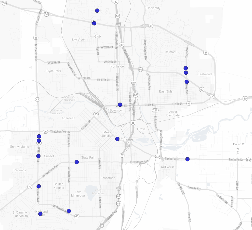
Here’s a map of the 15 robberies that have occurred in Pueblo over the course of the past 3 weeks. The map would suggest that criminals are targeting store locations with easy access to major transportation arteries including Pueblo Blvd., I-25 and US-50.
Data sources: list of robbery locations was found posted on David Ortiviz’s Facebook page; map produced using MarketSeer, which utilizes Google Maps.
6 Comments
I’ve read law enforcement reports indicating that the same occurs with car theft. Nearby highway entrances make for quick getaways. Of course, it’s also where the biggest targets are, considering that most major malls and office complexes are right off the highway. And finally, the physical environment in those types of locations enables carjackers to more easily hide or pretend like they belong there, something that is more difficult to do in residential areas.
Makes sense. Thanks for the comment!
As Hans mentioned, stores usually are closer to major arterial roads. Quick analysis: contrast with negative data (similar stores that have NOT been hit by robberies), with a simple test(even a t-test of mean distance) to see whether the targeted stores are actually closer to arterial roads than non-targeted stores.
Good idea, Mark! Although to do it correctly, I would need to gather a lot more data…and that means trying to pry it from some city govt official. Not sure when I’ll have time. Any Pueblo PD or City Govt folks want to send me robbery incident data for all of 2012? [Not holding my breath] Thanks again for the suggestion, Mark. Cheers, J.
I agree with Mark. My city here will only zone for businesses on arterial streets. Ergo, if thieves are to target businesses, they are already geographically placed on an arterial street to begin with.
Another question that would need to be asked: Is this data truly limited to retail robberies, or does it include person-on-person robberies as well?